

THE UK could face nine consecutive days of snow, with weather models suggesting that up to 30 inches may accumulate across the country, including major cities such as London, Birmingham, Manchester and Edinburgh.
Advanced GFS model maps indicate that wintry conditions will begin late on 27 January, as a storm sweeps in from the Atlantic, bringing snow to Northern Ireland, Wales and the south-west of England. The flurries are then expected to move eastwards on 28 January, reaching Scotland, the Midlands and the south-east, putting Glasgow, Edinburgh, Birmingham and London in the potential path of snowfall.
By the evening of 29 January, southern England could see heavy snow, with Plymouth, Bristol, Southampton and London all at risk of accumulation.
The north-east of England is predicted to experience the most intense snowfall on 30 January, with Newcastle, Aberdeen and Dundee likely to see severe flurries. Lighter snow may also fall across East Anglia.
On 31 January, the GFS model shows snow spreading across much of England once more, affecting East Anglia, the Midlands and southern regions, with London again potentially in the firing line.

Sporadic flurries are forecast to continue across Northern Ireland, Wales, northern and central England, and Scotland on 1 and 2 February. Heavy snow is expected to return to northern England on 3 February, with Newcastle again facing the most intense conditions.
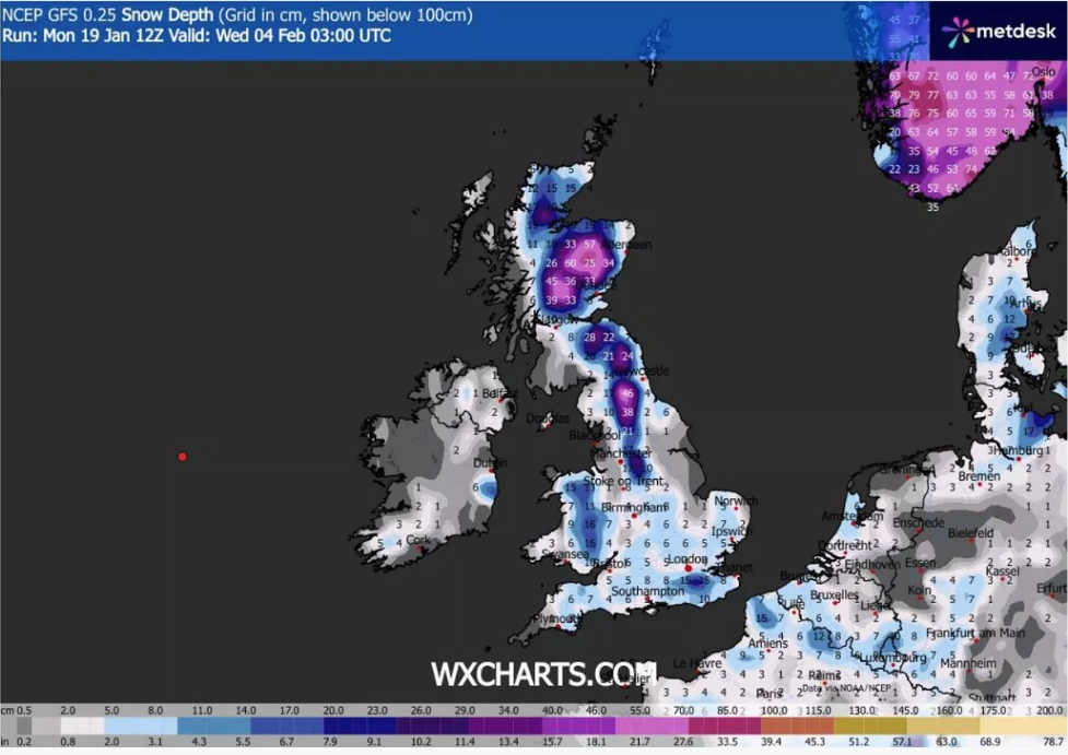
By the morning of 4 February, snow coverage maps suggest that every part of the UK could have some snow on the ground, with flurries continuing in northern regions and Wales. Snow depth charts indicate that the Scottish Highlands could see up to 75cm (around 30 inches) of accumulation over this nine-day period. Northern England may see up to 46cm (18 inches), with Wales and the south-east of England potentially receiving 16cm (approximately six inches). The Midlands and south-west are expected to receive 7–8cm.
The Met Office has also forecast snow towards the end of January and into early February, although it currently does not anticipate such widespread flurries.
In its outlook for 24 January to 2 February, the Met Office stated:
*”The UK will likely remain caught between Atlantic weather systems pushing in from the west and high pressure to the north and northeast, causing systems to stall. Spells of rain or showers are expected, which may be heavy and persistent, particularly in the south and west, while drier conditions are most likely in the far north and northwest.
“Temperatures will occasionally rise in the south and west, but it is likely to turn colder overall during this period, bringing the risk of snow, especially on hills in Scotland and northern England.”*